Author: Maria Daugherty
Site Name: Walla Walla Basin Watershed Council
Location: Walla Walla River Watershed located in Washington and Oregon
Operators: Walla Walla Basin Watershed Council (WWBWC), Hudson Bay District Improvement Company, Fruitvale Water Users Association, and Walla Walla River Irrigation District.
Permitting Agencies: Oregon Department of Water Resources and Washington Department of Ecology
Current MAR Status: Active
Year Constructed: 2004
Costs: $10,000/year for the operation and maintenance of all Oregon recharge sites
Project Contact Information: Walla Walla Basin Watershed Council (541-938-2170)
Project Website/Publication Links:
https://wwbwc.org/index.php/recharge#anspach
Purpose of MAR:
- Water supply resilience
- Protection of riparian ecosystems/maintenance of minimum streamflow
- Resilience/climate adaptation
Source Water:
- Rivers/streams/lakes/reservoirs
Water Quality:
- No treatment required
Recharge Technology:
- Infiltration basin
- Infiltration gallery
Project Description
Aquifer and watershed boundaries rarely follow political borders, yet political borders often dictate the occurrence of MAR locations. In the Walla Walla watershed, collaboration among landowners, state agencies, and others helped the Walla Walla Basin Watershed Council (WWBWC) develop an effective bi-state recharge project to enhance the Walla Walla River. The WWBWC works to protect the Walla Walla River system, which is located in northeast Oregon and southeast Washington. An underlying alluvial aquifer maintains a high degree of hydraulic connectivity to the streams on the valley floor and generally follows a predictable path from east to west but is a transboundary watershed shared by the states of Oregon and Washington (Figure 1).

Figure 1. Distributary stream network of the Walla Walla River, which is a transboundary watershed shared by the states of Oregon and Washington.
Source: WWBWC (2020)
An increase in development caused water levels in the Walla Walla River to drop, which degraded habitat conditions for steelhead and bull trout, ultimately resulting in both species being categorized as threatened under the Endangered Species Act. Although initial measures were taken to recover streamflow conditions, with irrigators agreeing to leave surface water in the river, streamflows were still insufficient for aquatic life. In addition to restoring lost floodplain function due to channelization and flood control, it was determined that groundwater mitigation was required to achieve river restoration, as it was estimated that seepage loss to groundwater along some stretches of the river was greater than 30% (Figure 2).

Figure 2. Average gains or losses in flow of a segment of the Walla Walla River during seepage runs conducted 2004–2016. Gains (positive values are greens and yellows) indicate groundwater discharging to the river. Losses (negative values are reds and oranges) indicate surface water seeping into the ground.
Source: WWBWC (2017)
The WWBWC created an aquifer recharge project to address declining groundwater conditions; however, since the watershed and alluvial aquifer cross state borders, it became apparent that a bi-state approach would increase ecological benefits gained through multiple MAR locations (Figure 3). A total of 19 recharge projects have been implemented throughout the Milton-Freewater alluvial fan via infiltration galleries and ponds designed to recharge the aquifer. From 2004 to 2020, approximately 85,000 acre-feet of recharge volume has been added into the Walla Walla Basin from the Oregon MAR project (Figure 4).
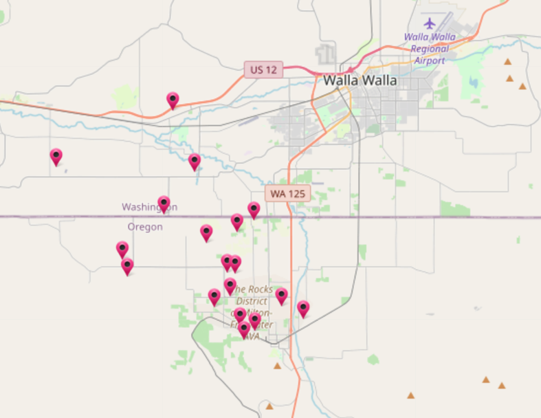
Figure 3. Recharge locations of the WWBWC.
Source: WWBWC (2023)
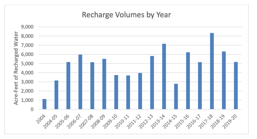
Figure 4. Cumulative recharge volume of the Oregon Walla Walla Basin MAR project (14 recharge sites).
Source: WWBWC (2020)
Currently, the sites are operated under a limited license issued by the Oregon Water Resources Department. Recharge operations in Washington are on hold due to various issues, such as maintenance to prevent clogging, grant money tied directly to fish habitat restoration (rather than MAR operations), and the changing of property ownership. When Washington recharge sites are in operation, the Washington Department of Ecology will oversee water quality criteria.
The variation in recharge water volume greatly depends on water availability and landowner participation; although some sites contribute relatively small portions to the aquifer, they were designed to recharge the alluvial aquifer via conveyance losses from open ditches when delivering water to the sites (Figure 5). Source water for 14 aquifer recharge sites in Oregon was obtained from the Walla Walla River in Milton-Freewater, Oregon, under a limited license agreement with the Oregon Water Resources Department and delivered throughout existing irrigation delivery systems to each site’s turnout.
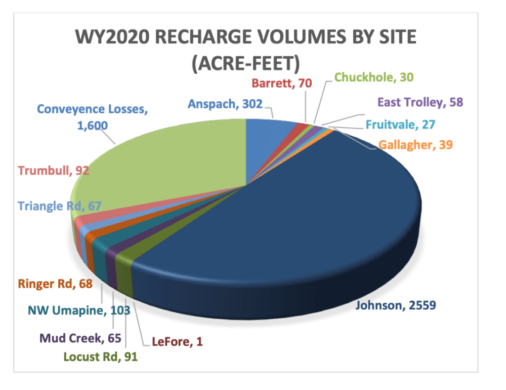
Figure 5. Recharge volumes by site during water year 2020.
Source: WWBWC (2020)
The Johnson site (Figure 6) is the largest recharge location, constructed in 2004, and includes 10 spreading basins and three active infiltration galleries. The site was developed under a phased approach that involved the initial construction of the infiltration basins, with the final phase including the addition of infiltration galleries (Figure 7). The four different infiltration gallery designs were installed to create a cost-benefit analysis of the different design types to determine each design’s longevity. From 2004 to 2020, the Johnson site has recharged over 51,000 acre-feet.
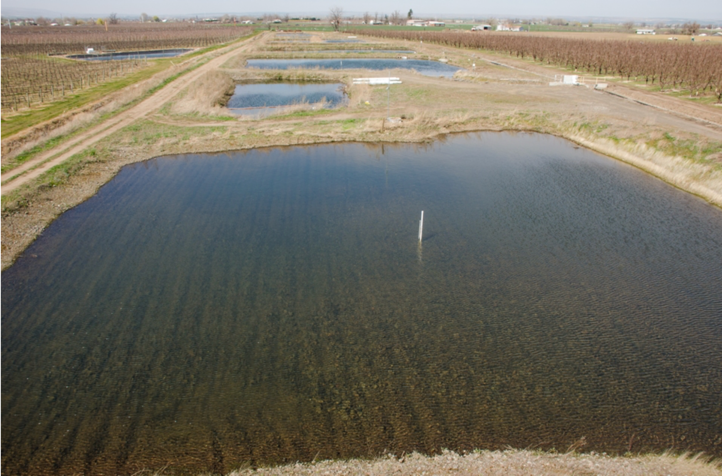
Figure 6. The Johnson Aquifer recharge site.
Source: WWBWC (2023).
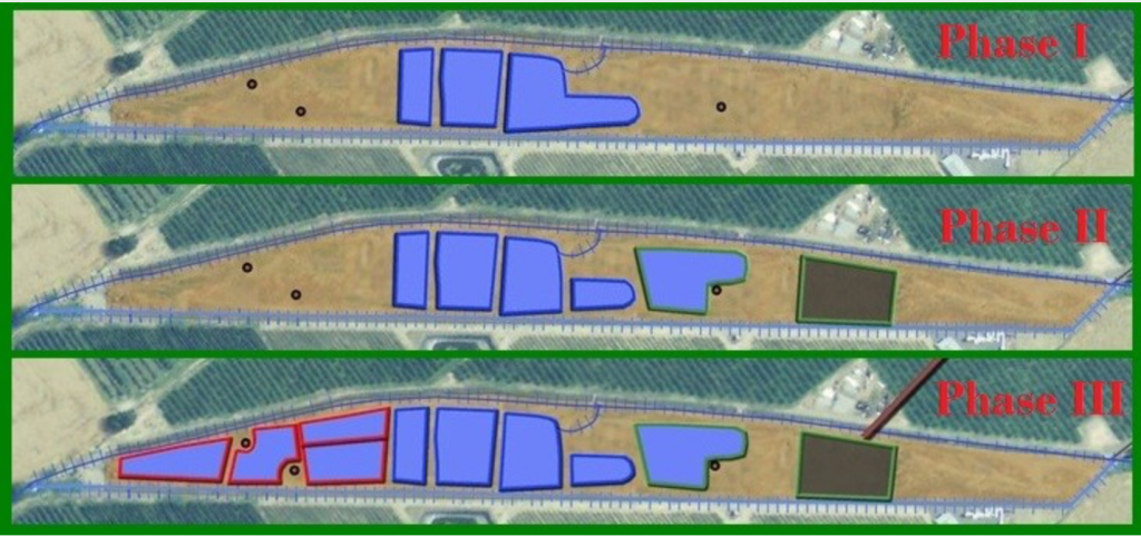
Figure 7. Phased approach of MAR at the Johnson site.
Source: WWBWC (2023)
Lessons Learned
Groundwater declines in the Walla Walla Basin have caused springs and domestic wells to dry up and have produced a steep gradient of seepage losses from the numerous hydraulically connected streams and rivers on the valley floor. In addition to restoring floodplain function lost with channelization and flood control, Walla Walla’s MAR project is a vital tool in the suite of restoration actions needed to improve in-stream flows and aquatic habitat for threatened and endangered native fish species.
Other Considerations
Considering the volumes of recharge versus achieving project success requires analysis of many factors, including realistic timelines. For example, the WWBWC 2013 Aquifer Recharge Strategic Plan stated that the following benefits were expected if annual volume recharged reached 20,000 acre-feet:
“Reversing the loss of storage within the alluvial aquifer will minimize seepage loss in the valley’s rivers and streams, increase spring performance and related groundwater input to surface water features, and allow groundwater resources of the alluvial aquifer to continue to be used as a sustainable resource with a secondary or alternative-use benefit to surface water.” (WWBWC 2013, p. 79).
To date, the target volume has not yet been achieved (Figure 4); however, the foundational structure exists to achieve this goal, because collaboration among the WWBWC, state agencies, landowners, and other stakeholders in the watershed is in place to meet demand, while utilizing MAR to continue improving ecological conditions. The foundational structure of collaboration, especially in a transboundary watershed, is paramount to achieving measured success.

