Authors: Ian Magruder and Scott Payne
Site Name: Clark Fork River Basin MAR Modeling
Location: Deer Lodge, Montana
Operator(s): Montana Department of Natural Resources and Conservation and Clark Fork River Basin Task Force
Permitting Agency(s): Montana Department of Natural Resources and Conservation
Current MAR Status: Alluvial Water Accounting System (AWAS) MAR modeling is complete.
Year Completed: 2015
Costs: $50,000 total, approximately one-third or $17,000 for case study portion
Project Contact Information: Scott Payne, WWC Engineering, 406-842-7224 [email protected]
- Project Website/Publication Links: Clark Fork Kootenai (mt.gov); Clark Fork Water Supply Report Series I—Water Supply and Mitigation Options; Clark Fork Water Supply Report Series I—Attachment 1 Modeling Report
Purpose of MAR:
- Water supply resilience
- Protection of riparian ecosystems/maintenance of minimum streamflow
- Resilience/climate adaptation
- Agricultural
- Water rights permitting support
Source Water:
- Rivers/streams/lakes/reservoirs
- Agricultural return flows
Water Quality:
- No treatment required
Recharge Technology(s):
- Dry well
Project Description
Water availability in the Clark Fork River Basin in Western Montana is in short supply for new uses, including development, population growth, and fishery restoration projects. This case study evaluates how MAR can be used to support a project that would increase in-stream flow for fish in a dewatered river. We demonstrate using an analytical streamflow-groundwater model to assist with planning and permitting the project.
Figure 1 shows the many limitations on water availability for new uses and shows the location of this case study, near Deer Lodge, MT. The limitations on new water use include legislative and administrative rule closures and controlled groundwater areas, all of which are legal tools to protect existing uses in a watershed that does not have sufficient water to satisfy existing uses, a situation often referred to as overallocation. Existing water rights may also limit any newly permitted water use because those existing water rights must be satisfied first under the prior appropriation water right legal framework; these are referred to as limiting water rights. Montana, where the case study is located, uses the prior appropriation system, like most western U.S. states do.
Under Montana water law, where the existing water supply is overallocated, new and changed water use requires a mitigation plan to reallocate water and eliminate any depletion of surface water that would adversely affect another water user. The mitigation plan takes an existing permitted water use and changes it in a manner that protects all other existing water uses. MAR using retired irrigation water is commonly used to satisfy mitigation plans. The mitigation plan requires hydrological accounting for the changes in flows resulting from changes in water use, something that is far from simple to accomplish. New water uses have been stymied in part by the complexity of the water accounting required to permit a new or changed water use through Montana Department of Natural Resources and Conservation (DNRC).
To address this, DNRC, in coordination with the Clark Fork River Basin Task Force, funded a water supply report with the goal to demonstrate three different hypothetical mitigation scenarios (Kirk Engineering & Natural Resources, Inc. 2015a and Kirk Engineering & Natural Resources, Inc. 2015b). We refer to these in this case study as the DNRC publications. We modeled and authored the DNRC publications and present a summary of one of the scenarios here because it both highlights the benefits of MAR and demonstrates the use of modeling to evaluate and fine-tune a proposed application of MAR.
In the DNRC publications, both the MAR plan and the water right mitigation plan were developed using a computer program that performs the required hydrological accounting. Two of the hypothetical scenarios relate to mitigating residential development, and the third scenario evaluates improving in-stream flow for fisheries in a dewatered portion of the Clark Fork River, which is the topic of this case study.

Figure 1. Case study location and limitations on new and changed water use.
Source: Kirk Engineering & Natural Resources, Inc. (2015)
Model Description
The Alluvial Water Accounting System (AWAS) model (Schroeder 1987 and IDS Group 2013) was used. AWAS is a simplified analytical modeling tool, is open source, and is a good alternative to more complex and time-consuming groundwater models. AWAS is commonly used to simulate MAR in riverine and unconfined aquifer settings because local hydrogeologic conditions are reasonably approximated in this simplified model (Kirk Engineering & Natural Resources, Inc. 2015a; Milman, Bylo, and Blomquist 2021). The model is used to compute streamflow depletion or accretion caused by pumping a well or recharging an aquifer. The AWAS user manual and free software can be downloaded from the Integrated Decision Support Group, part of the Water Center at Colorado State University: The Integrated Decision Support Group—Projects (colostate.edu).
Project Planning—Water Rights
In Montana, the ability to obtain a water right for a new use is not solely based on whether water is “physically available” but is also governed by a host of complex state water right laws and regulations that identify whether water is deemed “legally available” in relation to any stream, river, or aquifer.
States that have a prior appropriation system like Montana will likely have similar but slightly different water permitting challenges to those described here. The prospective water planner must consider which water rights are available to change to mitigation and if those water rights can supply sufficient water in the timing, amount, and location required by law to protect other existing water rights. To this end, modeling MAR is a practical tool that can be used to plan and support a permittable new or changed water use. A brief review of legally available water is needed to provide context for how and why MAR is simulated for the case study.
In Montana, water right changes from irrigation to in-stream flow for fisheries can change the crop consumptive evapotranspiration portion of an existing water right to protectable in-stream flow below the point of diversion (§85-2-408, Montana Codes Annotated). We call these changes “protectable” in-stream flow because it is backed by a water right and junior appropriators can be called on to make sure the water remains instream.
“Return flow” in this case study means the groundwater recharge caused by irrigation inefficiencies, such as ditch leakage and field loss, that returns to surface water. Under Montana water law, water right changes must mitigate changes to agricultural return flows that would adversely affect other water rights holders. This is somewhat counterintuitive; a brief explanation is that the long history of irrigation practice in Montana is itself a primary source of recharge to groundwater and that recharge bolsters streamflow, especially during late summer when streamflow is most limited. Our modeling analysis is in part focused on mitigating any reduction in agricultural return flow for which another appropriator has a water right.
The water rights analysis is further complicated by the requirement to consider the irrigated evapotranspiration and groundwater agricultural return flow as they existed in 1973 when the Montana Water Use Act became law. This is a nuance of Montana water law that exists because the Water Use Act essentially sets water rights in stone as of the 1973 date, even though the law allows any irrigator to change the method of irrigation, such as changing flood to center pivot to allow for modernization of farm production and greater irrigation efficiency. Once a person seeks to change that water right—for instance, from irrigation to an instream use—the water right changes, and the mitigation plan must consider the water right as it existed in 1973.
Modeling a Water Use Change from Irrigation to In-stream Flow in Deer Lodge, Montana
The modeling in this case study simulates a water right change from irrigation to in-stream flow augmentation for fisheries along a dewatered reach of the Clark Fork River. The Clark Fork River is chronically dewatered in this reach during summer irrigation season, and just several weeks of extremely low flow and high-water temperature can severely impact the fishery. It is common for conservation interests to seek to buy irrigation water and change the water rights into a protectable in-stream flow to maintain a minimum flow in the river that supports fish.
The modeled scenario takes a portion of a 290-acre irrigated hayfield out of production and looks at three potential alternatives for changes to the water right and mitigation. Each alternative is modeled to see if it meets the legal requisite of no net depletion that adversely affects other water rights, as required by the governing water law. The alternatives are as follows.
Alternative 1. Retires 50 acres of the current pivot acreage and leaves the irrigation water in stream.
Alternative 2. Retires sufficient acreage from current center pivot to create a minimum of 0.5 cfs of protectable in-stream flow during August and attempts to mitigate the change in agricultural return flow by leaving the irrigation water in stream.
Alternative 3. Retires sufficient acreage from current center pivot to create a minimum of 0.5 cfs of protectable in-stream flow during August and mitigates the change in agricultural return flows with MAR by routing irrigation water into a drainfield.
Streamflow reduction in the Clark Fork River is not allowed from July through March due to other limiting water rights., further details of which are provided in the DNRC publications.
The historic water use of this water right was flood irrigation beginning in 1870, but it was changed to center-pivot irrigation in the early 1990s. The change to center-pivot irrigation radically changed the amount and timing of water use, the area irrigated, and the groundwater agricultural return flow. All the changes caused by this previous change to more efficient center-pivot irrigation must be accommodated in the mitigation plan.
Streamflow changes under the three alternatives were evaluated monthly, assuming evapotranspiration and agricultural return flows are relatively consistent over the course of a month. The modeled streamflow change stabilizes to a new equilibrium condition approximately 6 years after the irrigation change owing to the time it takes groundwater head to equilibrate.
The modeling exercise shows that the first two alternatives are not feasible because streamflow is depleted in a manner that impacts existing water rights. Only Alternative 3 mitigates streamflow depletion during the months of October to March, because the irrigation water right can be recharged during the May through October period of use allowed for the water right. We describe only Alternative 3 in detail here because it is most relevant to the topic of MAR. Detailed results for Alternatives 1 and 2 are available in the DNRC publications. Alternative 3 meets both legal requirements of no stream depletion from July through March and the project goal of increasing streamflow by 0.5 cfs during August, when low flow and high-water temperature are most damaging to the fishery, as shown in Figure 2.

Figure 2. Modeled net change in streamflow under each alternative.
Depletion from loss of agricultural return flow is shown in Figure 2. Similar to Alternative 1, depletion from changes in agricultural return flow are mitigated during June through September by leaving currently applied irrigation water in stream (Figure 3). Changes in agricultural return flows are not mitigated from October through March again because of the limitation of using a seasonal irrigation water right to mitigate a year-round reduction in agricultural return flow. Like Alternative 1, Alternative 2 fails to meet legal requirements to protect existing water rights, demonstrating that a different mitigation plan is needed.
Under Alternative 3, the water formerly applied to the retired acreage is discharged to groundwater via a large drainfield, similar to a septic system. A drainfield is a practical method of performing MAR because it does not require the high-pressure pumping apparatus and energy needed for injection wells. Additionally, infiltrating water underground eliminates the evaporation loss that exists in a surface infiltration basin. The drainfield can both have lower long-term costs and be more water-efficient than these other MAR techniques.
Recharge from the drainfield joins the natural groundwater flow toward the Clark Fork River. The location, timing, and intensity of recharge is analyzed using the model so that streamflow depletion is mitigated using the minimum amount of MAR necessary.
The model allows fine-tuning of the recharge timing and rate using the minimum amount of recharge water necessary (see Figure 3). The fine-tuning that is possible with the model increases water efficiency and lowers costs associated with MAR. As required under law, the entire historic agricultural return flow under flood irrigation is mitigated, even though much of the historic flood agricultural return flow was eliminated in the 1990s when the field was converted to center-pivot irrigation.
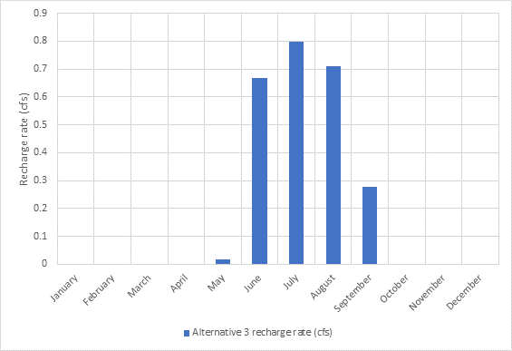
Figure 3. The MAR rate uses the most efficient application of water to meet both project goals and regulatory requirements.
Modeling also demonstrates that the drainfield location affects how efficiently MAR mitigation works. With the drainfield located at the upper end of the field farther from the river, mitigation during summer months is inadequate even when the entire water right allowance for June is infiltrated through the drainfield. With the drainfield located at the upper end of the field, mitigation of agricultural return flow changes would require additional irrigation water to be infiltrated during July and August, which in turn reduces water available to less than the 0.5 cfs in-stream flow target for August. The model shows that locating the drainfield in the middle of the retired field results in adequate mitigation while minimizing the amount of irrigation water that needs to be recharged and maximizing water available for in-stream flow.
Discussion
Modeling demonstrates that MAR proposed in Alternative 3 provides the only viable solution of the three alternatives to meet a specific target for protectable in-stream flow. Figure 3 shows that while increases to Clark Fork River streamflow from Alternatives 1 and 2 are greater than Alternative 3 during summer, Alternatives 1 and 2, which do not employ MAR, fail to mitigate all agricultural return flow loss during October to March and cannot be permitted by DNRC because it would adversely affect other water rights. Modeling the project alternatives with AWAS provides a simple yet effective method to assess and quantify how MAR can offset changes to irrigation agricultural return flow magnitude and timing. The model also allows the water planner to develop a plan to meet a targeted in-stream flow augmentation that maximizes water efficiency and minimizes costs associated with MAR.
The DNRC publications are available at the following website under the pull-down menu for Surface Water Reports: Clark Fork Kootenai (mt.gov).
Look for the following titles:
- Clark Fork Water Supply Report Series I—Water Supply and Mitigation Options
- Clark Fork Water Supply Report Series I—Attachment 1 Modeling Report
In addition to the Deer Lodge scenario described here, the reports examine an application of MAR to provide water for a hypothetical residential development in the Bitterroot Valley of Montana.

