Author: Anthony Daus
Site Name: Salinas Valley Groundwater Basin
Location: Monterey County, California
Operator(s): Monterey County Water Resources Agency (MCWRA) and the Salinas Valley Basin Groundwater Sustainability Agency
Permitting Agency(s): California State Water Resources Control Board, California Department of Water Resources, National Oceanic and Atmospheric Administration (NOAA), Federal Energy Regulatory Commission (FERC), and U.S. Army Corps of Engineers
Current MAR Status: Active MAR release of stored surface water from two large reservoirs
Year Constructed: 1957—Nacimiento Reservoir; 1967—San Antonio Reservoir
Project Contact Information: MCWRA, (831) 755-4860
Project Website/Publication Links:
- https://www.co.monterey.ca.us/government/government-links/water-resources-agency
- https://svbgsa.org/about-us/
Purpose of MAR:
- Water supply resilience
- Use of floodwater (control of flood, agricultural)
- Protection of riparian ecosystems/maintenance of minimum streamflow
Source Water:
- Rivers/streams/lakes/reservoirs
- Captured water (floodwater, stormwater, precipitation/overland flow/runoff, harvested rainwater)
Water Quality:
- No treatment required
Recharge Technology(s):
- Enhanced streambed recharge
Project Description
The Salinas Valley is the largest coastal groundwater basin in Central California and one of the most important agricultural areas in California. The northwest-trending valley is V-shaped with mountains on the southwest and northeast emptying into the Pacific Ocean near Monterey, California. The valley is drained by the Salinas River and its tributaries and includes rangeland, intensive year-round agricultural activities, and urban development.
Groundwater in the basin is divided into four subareas that include both confined aquifers in the north and unconfined aquifers in the south (Figure 1). The areas are extensively used for agriculture and include several urban areas, including the City of Salinas. Groundwater pumping dates to approximately 1890 and is used for municipal supply and irrigation. As a result, parts of the basin are in overdraft with seawater intrusion extending up to 8 miles inland from the coast.
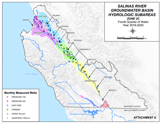
Figure 1. Salinas River Groundwater Basin and hydrologic subareas.
Source: Monterey County Water Resources Agency (2023)
Recharge from streams represents 50% of the average 504,000 acre-feet/year of annual recharge to the groundwater basin. The flow in the Salinas River is managed using two reservoirs, the Nacimiento and San Antonio reservoirs. The water collected and stored by the reservoirs originates as runoff from the coastal mountain range to the west. The reservoirs are managed for multiple purposes, including groundwater recharge, flood control, and to sustain native steelhead populations (an anadromous fish). There are current plans to construct an interlake tunnel that will allow MCWRA to transfer water from Nacimiento Reservoir to San Antonio Reservoir. This $48,000,000 project will allow the MCWRA to store additional water for release during dry periods.
Receiving Aquifer
The basin is divided into four subbasins or subareas. From south to north the subbasins include the Upper Valley, Forebay, Pressure, and Eastside subareas (Figure 2). The Upper Valley and Forebay subarea aquifers are unconfined and recharged primarily by the Salinas and Arroyo Seco rivers and to a lesser degree by direct precipitation. The East Side subarea is unconfined and semiconfined and recharged by direct precipitation, while aquifers in the Pressure subarea are confined and semiconfined and subdivided into the shallow aquifer, the 180-foot aquifer, the 400-foot aquifer, and the deep aquifer (Figure 2). The Pressure area aquifers are recharged by underflow from the adjacent Forebay area. The basin is currently experiencing a long-term decrease in aquifer storage due to overpumping. The Pressure and Eastside subareas are experiencing saltwater intrusion from the Pacific Ocean due to overpumping.
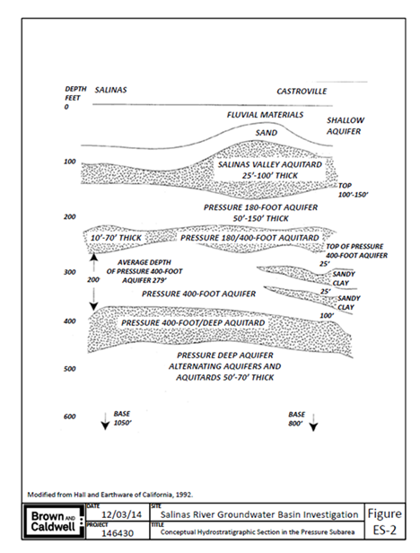
Figure 2. Aquifers in the Pressure subarea.
Source: Brown and Caldwell (2015)
Water Quality
The Salinas Valley Groundwater Basin is impacted by nitrates throughout; they are particularly high in the East Side, Forebay, and Upper Valley subareas. There are active programs to reduce the spread of nitrates by mitigating sources and removing abandoned or inactive wells that provide for vertical migration of shallow impacted groundwater to deeper water-bearing zones. Saltwater intrusion in the Pressure and Eastside subareas (north) has significantly impacted a large part of the coastal portions of the basin (Figure 3). Saltwater intrusion started in the 1930s and continues to extend into the basin with time. Efforts to control saltwater intrusion have consisted of reducing groundwater extractions in the Pressure subarea through in lieu recharge (providing recycled water and surface water in lieu of groundwater pumping) and groundwater pumping reductions.
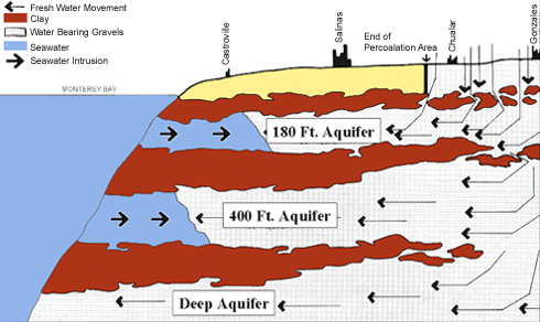
Figure 3. Seawater Intrusion into the Salinas Valley Groundwater Basin
Source: Monterey County Water Resources Agency (2023)
Performance to Date
Between April and October, the reservoir releases water to the Salinas River, resulting in recharge through the bottom of the streambed. In 2021, these losses through the bottom of the Salinas streambed amounted to approximately 1,237 acre-feet per day. Saltwater intrusion continues to impact the northern portion of the basin with efforts underway to reduce its progression. Efforts to reduce saltwater intrusion include providing recycled wastewater for use as irrigation water and the operation of the rubber dam to seasonally store Salinas River water for delivery as irrigation water, thus reducing the need to pump groundwater (in lieu recharge). Future surface water diversions are planned to divert up to 135,000 acre-feet per year of Salinas River water to reduce groundwater pumping in the northern part of the basin. Overall portions of the basin remain in overdraft due to the intensive groundwater pumping to support the agricultural interests. Steps are currently underway under the Sustainable Groundwater Management Act (SGMA) to make the groundwater supply a sustainable resource.
Regulatory Considerations/Issues
Permitting: Permitting agencies include, but are not limited to, the U.S. Army Corps of Engineers, NOAA, FERC, the State Water Resources Control Board, the California Department of Water Resources, and the California Department of Fish & Wildlife
Water Rights: Groundwater in the basin is not adjudicated but is subject to the Sustainable Groundwater Management Act of 2014 (DWR 2023).
Accounting: Surface water resources in watershed are managed by the Monterey County Water Resources Agency, and groundwater resources are managed by the Salinas Valley Basin Groundwater Sustainability Agency (SVBGSA) under SGMA.
Operational Considerations/Issues
Releases from the reservoirs are operated under separate rule curves established for each reservoir. The SVBGSA manages the groundwater basin and is tasked with implementing the Groundwater Sustainability Plan with sustainability reached by 2040. Given the integrated nature of surface water and groundwater resources, there are nearly 30 stakeholders involved in the management of water resources in the Salinas Valley. This requires frequent communication and outreach on all decision-making.