Author: John Lambie, principal hydrogeologist
Site Name: Mustang Creek
Location: Merced County, CA
Operator(s): Eastside Water District
Permitting Agency(s): State Water Board and Merced County Department of Environmental Health
Current MAR Status: Pilot study
Year Constructed: 2020
Costs: Not available
Project Contact Information: John Lambie
Project Website/Publication Links: NA
Purpose of MAR:
- Water supply resilience
Source Water:
- Captured water
Water Quality:
- Pretreatment required
Recharge Technology(s):
- Dry well
Project Description
The Mustang Creek project is located near East Avenue and Oakdale Road in Merced County, California. It is a pilot study designed to establish whether dry wells can be cost‐effective in introducing captured floodwater into the Turlock Subbasin Aquifer. Project data, including impacts to baseline water quality, infiltration and cost-effectiveness of dry wells, and the ability to introduce water to the subsurface into different geological strata, will be collected over a period of 2 years.
Three dry wells with flow meters are installed (Figure 1) at various depths and monitored for (1) surface water quality for mineralogy, (2) groundwater chemistry for changes in ions and inorganics in first groundwater, (3) the quantity of water infiltrated, and (4) groundwater hydraulic heads in the local and nearby region (Figure 2).
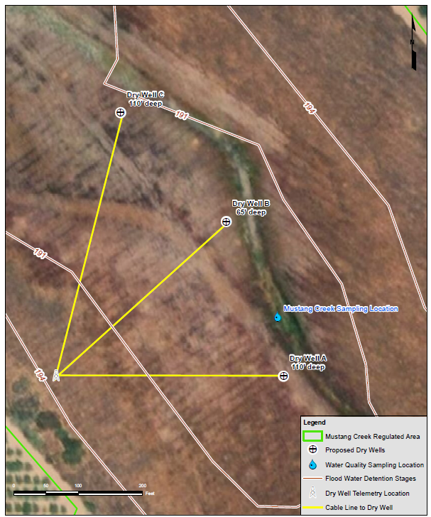
Figure 1. Installed dry well locations and depths.
Source: Lambie (2020)
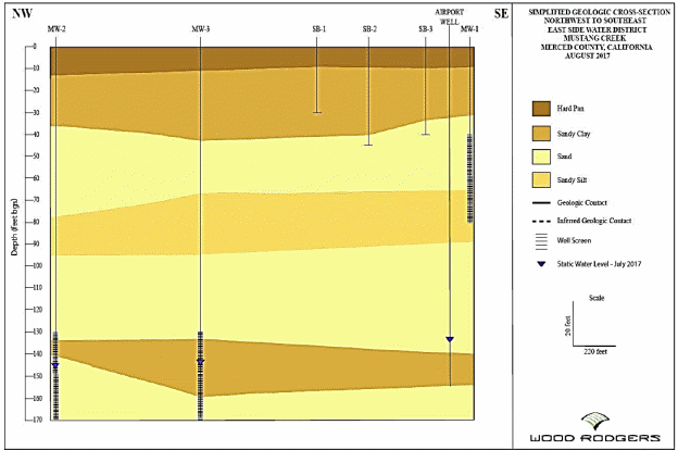
Figure 2. Geologic cross section at project site.
Source: Lambie (2020)
Receiving Aquifer
The Turlock Subbasin is defined and regulated under California’s Sustainable Groundwater Management Act (SGMA) (Figure 3). The SGMA requires that groundwater sustainability plans (GSP) be developed by local groundwater sustainability agencies so that groundwater conditions are not adversely impacted in the Turlock Subbasin. Further, the SGMA requires that water supply and demand met by groundwater usage is sustainable over the long term. This pilot project for dry wells and the broader program of intentional and MAR projects will be important components in the GSP water budgets. This can help water users of all types better manage water resources within the area to withstand droughts and minimize the need to fallow land or alter land uses due to a lack of water supplies.
There are five relatively small watersheds within the basin where surface and near‐surface conditions may be conducive to groundwater recharge above native or existing conditions of recharge. In these watersheds native surface water may be available as floodwater or diffused stormflow (water that does not and cannot reach a watercourse). These five watersheds range in size from 6.5 square miles to 21.5 square miles, with the largest of them being Mustang Creek.
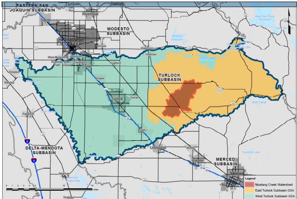
Figure 3. Location of receiving aquifer, Turlock Subbasin.
Source: Lambie (2020)
Water Quality
The USGS conducted extensive studies of groundwater and surface water in the region with a series of four or more focused on the water resources of Mustang Creek (Figure 4). The Eastern San Joaquin Water Quality Coalition has been conducting surface water quality testing of Mustang Creek since 2008. In 2014 the Eastside Water District (EWD) conducted investigations and preparatory work for some form of MAR at the secondary detention basin. Most recently, the East Turlock Subbasin Groundwater Sustainability Agency began a series of groundwater monitoring of their agency area, with three wells being monitored as of fall 2019 and another from the 2014 EWD work.
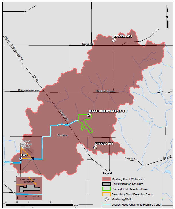
Figure 4. Mustang Creek watershed.
Source: Lambie (2020)
To provide the most relevant and recent assessment of water quality conditions in the detained waters of Mustang Creek, the engineer developed a baseline water‐quality standard in 2020, taking samples from the surface as well as from the USGS well. A full description of the sampling methods and results (general chemistry, pesticides, nutrients) can be found in Lambie (2020).
The field sampling scope for February 2020 was to collect one set of surface water quality samples from the primary detention basin on Mustang Creek and one set of groundwater quality samples from the USGS monitoring well at the primary detention basin (USGS MDB). Samples were also collected for baseline analysis of dissolved organic carbon, select metals, nitrogen, orthophosphate, major ions, biochemical oxygen demand (BOD), pH, and total dissolved solids (TDS).
The installed dry wells include a pretreatment chamber (Figure 5). The pretreatment chambers are designed to provide for surficial removal of sediment and organic debris but also to provide vadose zone treatment to percolating water before it reaches the groundwater table. This additional vadose zone treatment is important to reduce or mitigate water quality concerns associated with use of floodwater and other surface water.

Figure 5. Detail of installed dry well.
Source: Torrent Resources (2019)

Figure 5. Detail of installed dry well—cont’d.
Source: Torrent Resources (2019)
Regulatory Considerations/Issues
Current injection well regulations as defined by the U.S. Environmental Protection Agency require users to register dry wells as Class V injection facilities. Merced County Department of Environmental Health (MCDEH) as of September 2019 required that “recharge/injection wells” undergo a specific well construction/destruction permit process in accordance with Merced County Code (Chapters 9.27 and 9.28). The MCDEH permit process includes the establishment of and adherence to a monitoring and reporting program (MRP) as specified by the Central Valley Regional Water Quality Control Board (CVRWQCB). The CVRWQCB regards introduction of surface waters to dry wells as water and not waste or wastewater and develops appropriate MRPs to protect beneficial uses of groundwater.
Performance to Date
The dry wells are fed via gravity flow, and delivery of water is dependent upon rain events. Observed infiltration rates for a single dry well have exceeded 350 gallons per minute during significant rain events. Monitoring of infiltration rates is in real time.

